10 iconic American rivers to celebrate for National Rivers Month
Whether as a source of drinking water or travel, recreation or agriculture, rivers are central to the lives of billions of people worldwide.
The history of humans and their reliance on these waterways dates back thousands of years to when civilization first took root along the fertile banks of rivers like the Nile, the Yangtze, the Indus, the Tigris and the Euphrates.
In the United States, a 3.5-million-mile network of rivers has been indelibly woven into the fabric of life since before the founding of the nation. Today, the National Oceanic and Atmospheric Administration suggests that the vast majority of Americans live within a mile of a river or stream.
In honor of the nation’s 250th birthday and June being National Rivers Month, the following list highlights 10 prominent rivers that shaped — and continue to shape — the course of America.
America is a great story, and there is a river on every page of it.
Charles Kuralt
Journalist and author
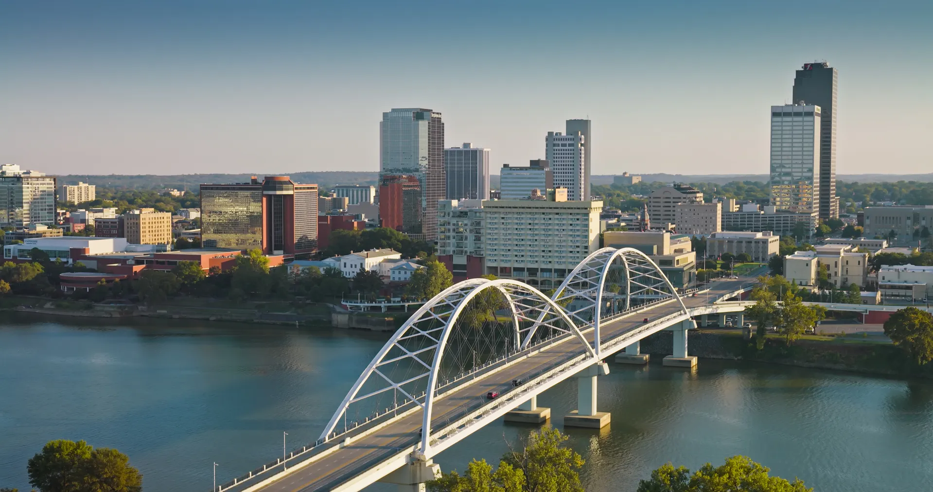
Arkansas River
- Length: 1,469 miles
- Course: Forms as snowmelt in the Coloradan Rocky Mountains and flows to the Mississippi River near Napoleon, Arkansas
- Size of watershed: 161,000 mi²
- States it touches: Colorado, Kansas, Oklahoma and Arkansas
- Nearby cities: Pueblo, Colorado; Wichita, Kansas; Tulsa, Oklahoma; Little Rock, Arkansas
- Imperiled species: Arkansas River Shiner (threatened), Peppered Chub (endangered), Alligator Snapping Turtle (threatened, pending)
- Why it’s important: A major tributary of the Mississippi River, the Arkansas River served as the U.S.-Mexican border from 1819 to 1846. It provided transportation, natural materials, food and water to Native Americans for thousands of years. Beginning in the 16th century, explorers such as Francisco Vasquez de Coronado, Hernando de Soto and Zebulon Pike used the Arkansas to venture deep into the Great Plains and the Southwest. The river remains a major resource for irrigation, livestock and crop production in these regions.
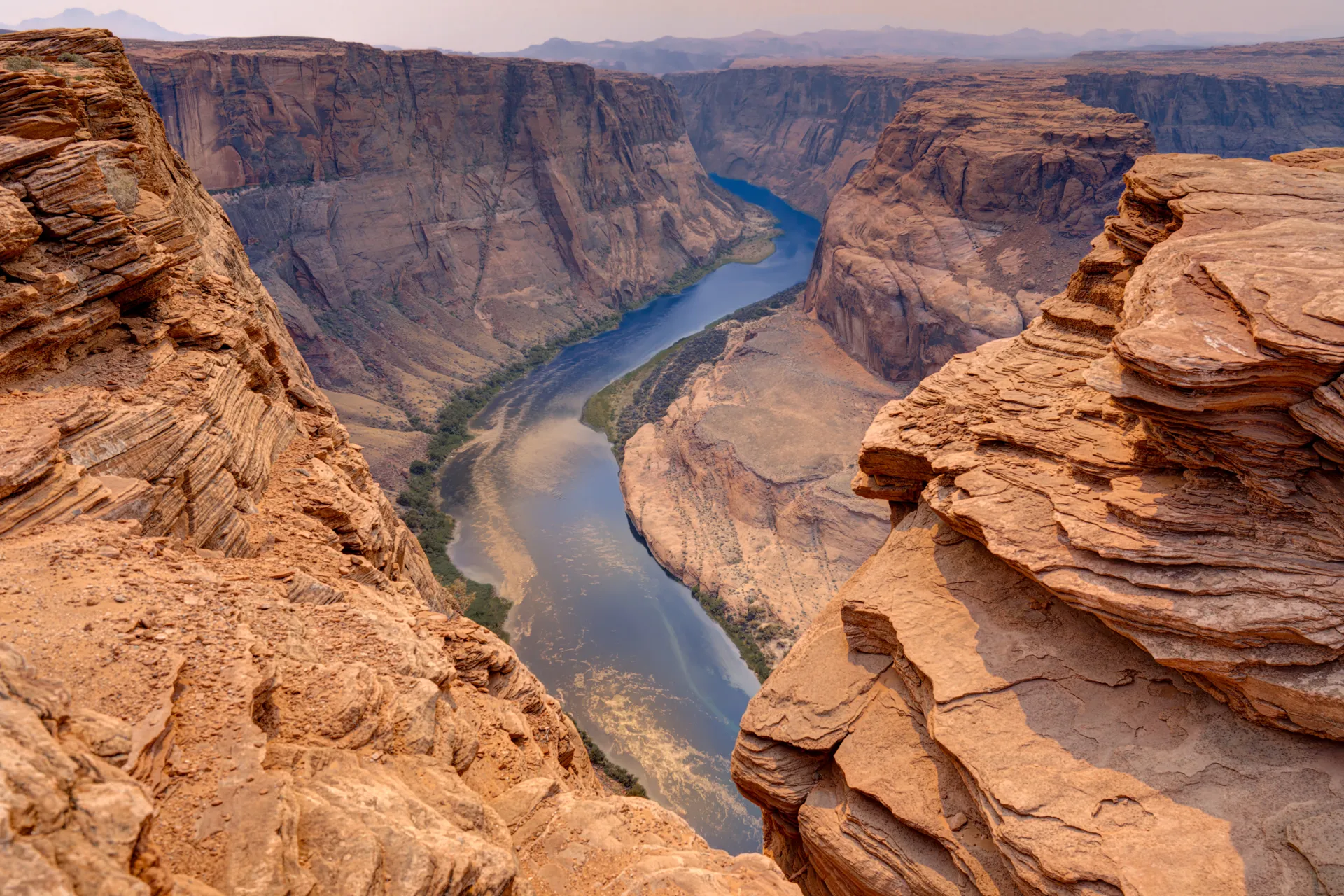
Colorado River
- Length: 1,440 miles
- Course: Flows from the Northern Coloradan Rocky Mountains to the Gulf of California in Baja California/Sonora, Mexico
- Size of watershed: 246,000 mi²
- States it touches: Colorado, Utah, Arizona, Nevada and California
- Nearby cities: Grand Junction, Colorado; Yuma, Arizona
- Imperiled species: Bonytail Chub (endangered), Colorado Pikeminnow (endangered), Humpback Chub (endangered) and Razorback Sucker (endangered)
- Why it’s important: From eroding the Grand Canyon to acting as a vital source of water and hydroelectric power, the Colorado is known as “the lifeline of the Southwest.” About 40 million people get their drinking water from the river, many via the 242-mile Colorado River Aquaduct. A changing climate and increased water use threaten wildlife habitat and the long-term viability of the river as a natural resource. The Colorado naturally drains into the Gulf of California, but thanks to rising demand, it now dries up more than 100 miles inland.
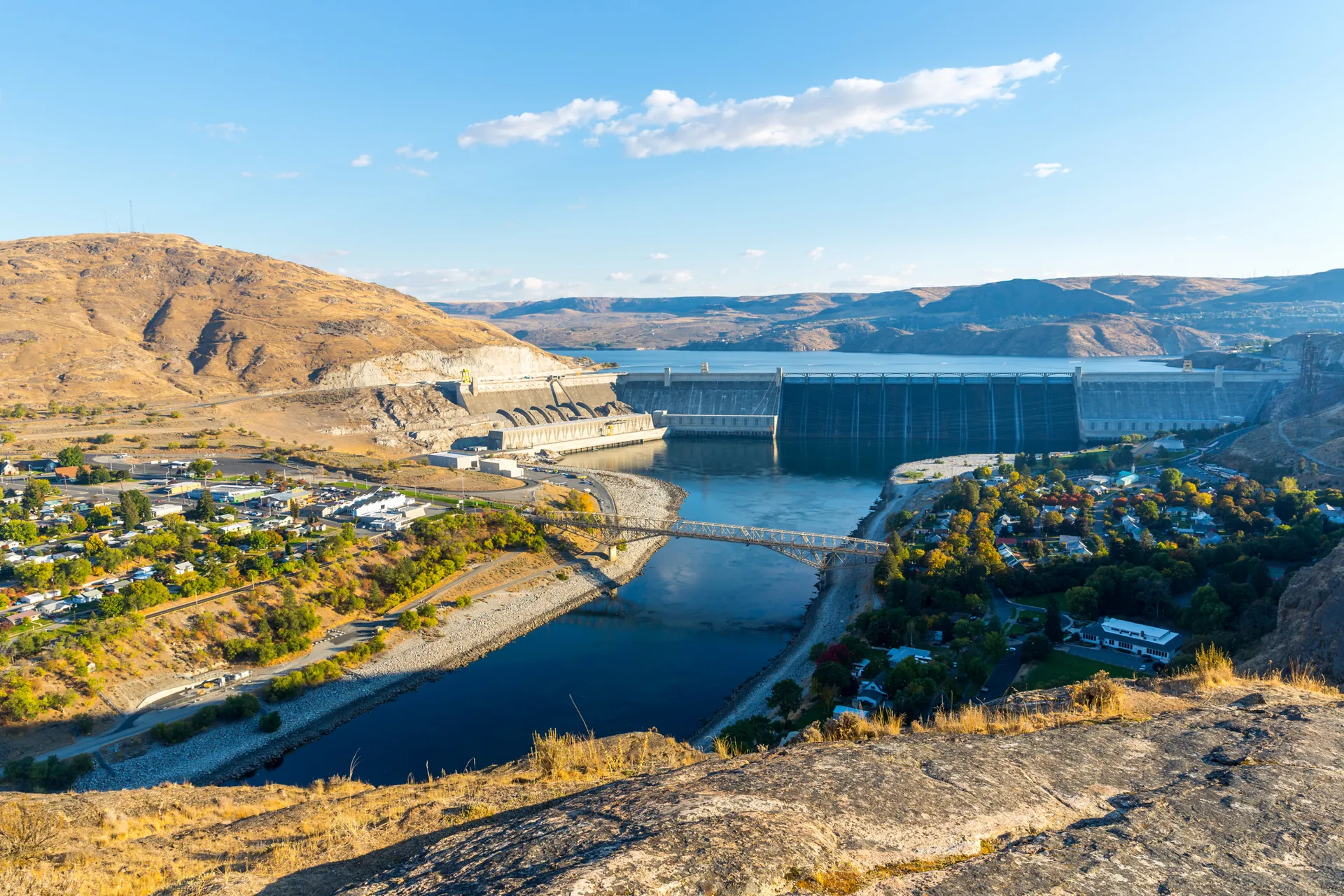
Columbia River
- Length: 1,243 miles
- Course: Flows from Columbia Lake in British Columbia to the Pacific Ocean near Astoria, Oregon
- Size of watershed: 260,000 mi²
- States it touches: Washington and Oregon as well as British Columbia, Canada
- Nearby cities: Vancouver, Washington; Portland, Oregon
- Imperiled species: Snake River Sockeye Salmon (endangered), Bull Trout (threatened), Green Sturgeon (threatened), Columbian White-tailed Deer (threatened), Northern Spotted Owl (threatened)
- Why it’s important: The Columbia River is the largest in the Pacific Northwest, draining an area roughly the size of France. In November 1805, Meriwether Lewis and William Clark’s expedition reached the Pacific Ocean near Astoria, Oregon, after navigating the lower reaches of the Columbia. Today, more than 60 dams in Columbia’s basin generate 36,000 megawatts of electricity — more than 40% of all U.S. hydroelectric power. Dams occur about once every 72 miles, fragmenting much of the river’s habitat and impeding migration by species such as Chinook, Sockeye and Coho salmon.
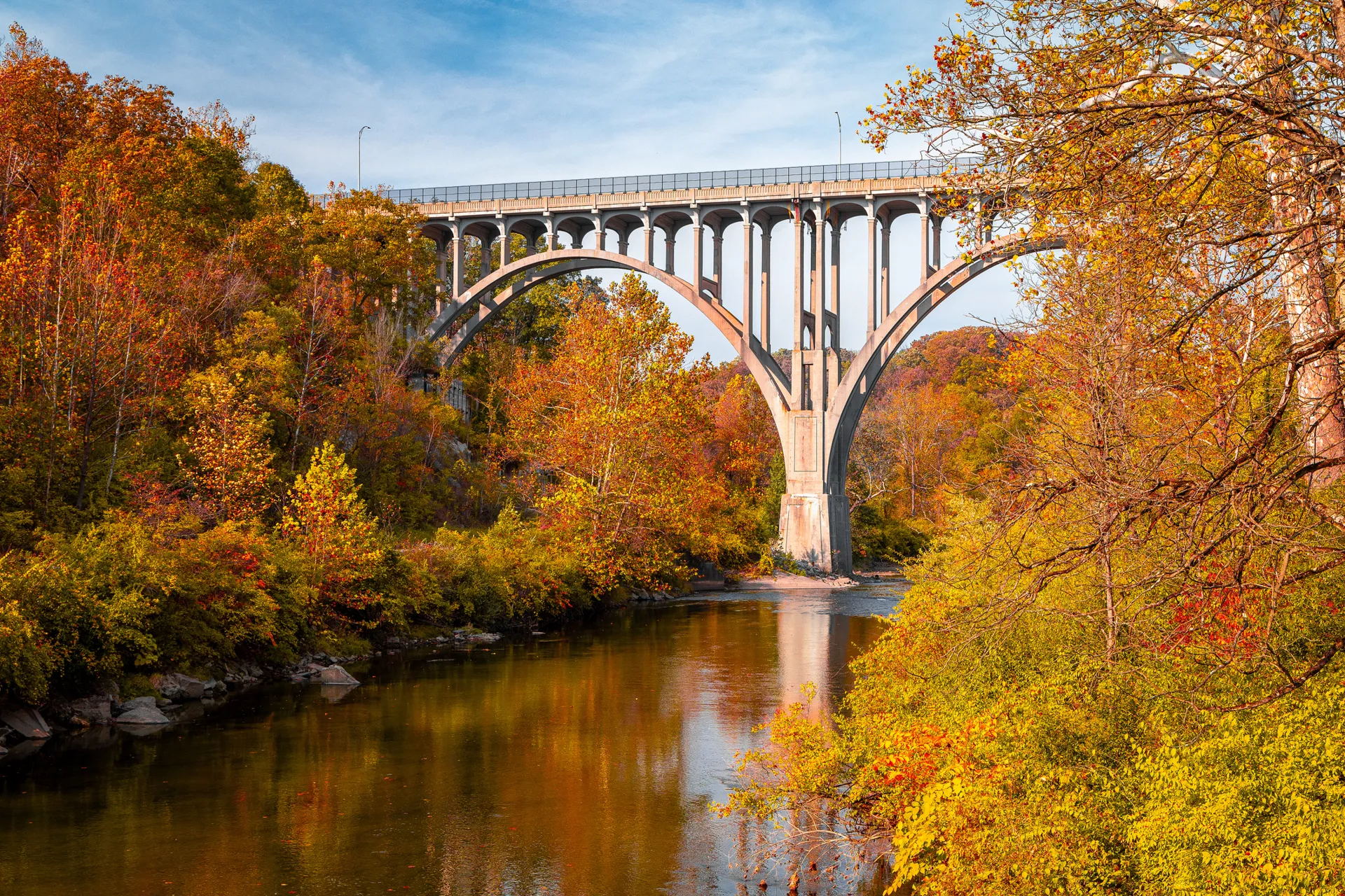
Cuyahoga River
- Length: 84.9 miles
- Course: Flows from the confluence of two smaller tributary branches in Geauga County, Ohio, to Lake Erie in Cleveland, Ohio
- Size of watershed: 813 mi²
- States it touches: Ohio
- Nearby cities: Akron, Ohio; Cleveland, Ohio
- Imperiled species: Lake Sturgeon (endangered in Ohio), Indiana Bat (endangered), Spotted Turtle (threatened in Ohio), Upland Sandpiper (endangered in Ohio), Smooth Green Snake (endangered in Ohio)
- Why it’s important: In the 20th century, heavy industrial buildup in nearby communities like Akron and Cleveland led to persistent oil slicks and debris that dramatically impacted the Cuyahoga’s water quality. Beginning in 1868, the river caught fire more than a dozen times. Coverage of the last fire in 1969 by Time Magazine attracted national attention and is credited with spurring environmental sentiment that led to the creation of the Environmental Protection Agency in 1970 and the passage of the Clean Water Act of 1972.
Delaware River
- Length: 330 miles
- Course: Flows from the Catskill Mountains of New York to Delaware Bay between New Jersey and Delaware
- Size of watershed: 13,539 mi²
- States it touches: New York, Pennsylvania, New Jersey, Delaware and Maryland
- Nearby cities: Philadelphia, Pennsylvania; Trenton, New Jersey; Wilmington, Delaware
- Imperiled species: Atlantic Sturgeon (endangered), Shortnose Sturgeon (endangered), Bog Turtle (threatened), Northern Long-eared Bat (threatened), Dwarf Wedgemussel (endangered), Pond Mussel (endangered)
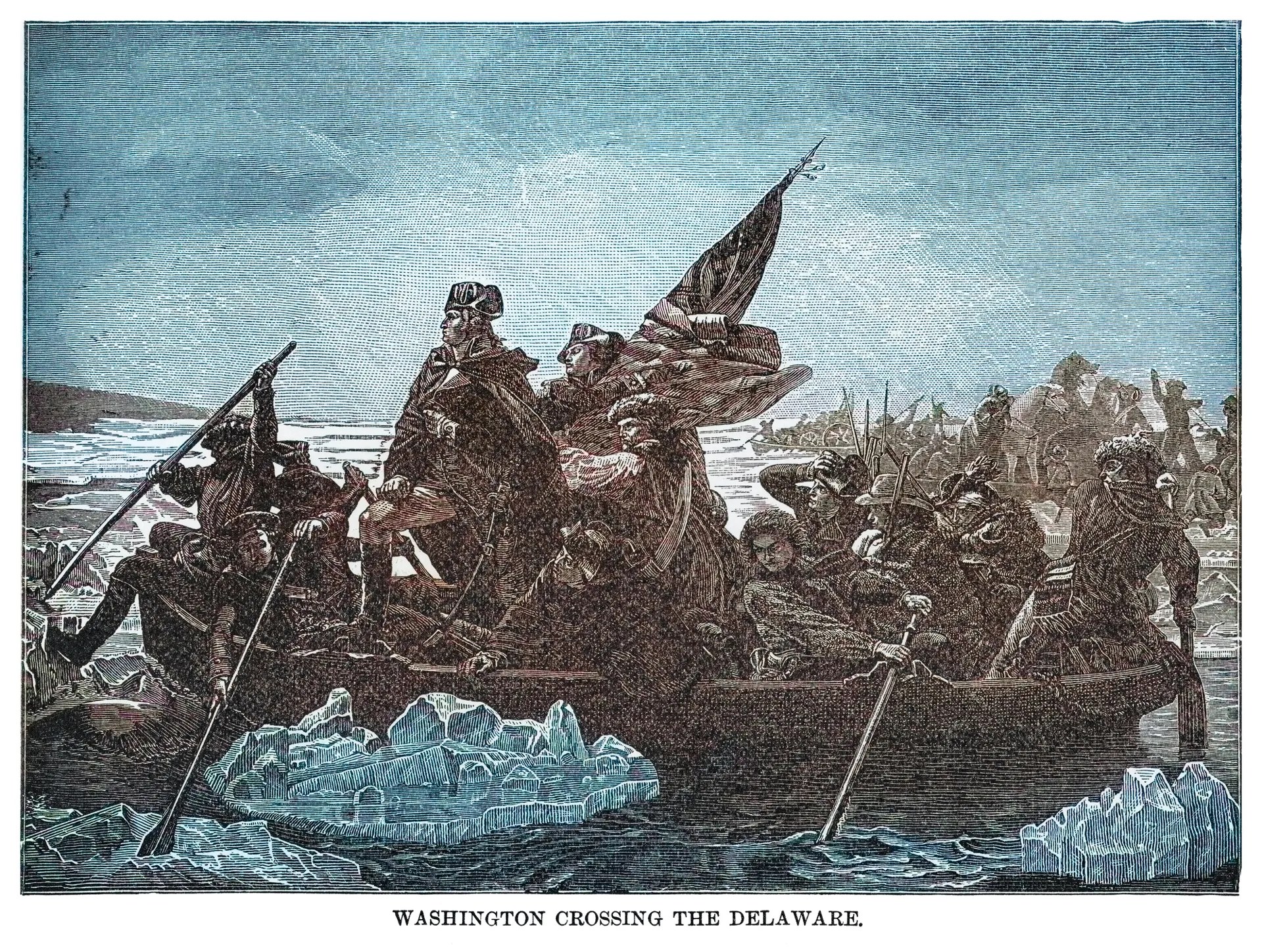
- Why it’s important: The Delaware River played a critical role in the Revolutionary War. As night fell on Christmas in 1776, Gen. George Washington led his troops on a daring river crossing to surprise Hessian mercenaries garrisoned in Trenton, New Jersey. This marked a critical turning point in the war to secure American independence. Today, the Delaware is the longest undammed waterway east of the Mississippi River and provides drinking water for 15 million people, including residents of New York City and Philadelphia.
Mississippi River
- Length: 2,350 miles
- Course: Flows from Lake Itasca in Northern Minnesota to the Gulf of Mexico in Southeastern Louisiana
- Size of watershed: 1.245 million mi²
- States it touches: Minnesota, Wisconsin, Iowa, Illinois, Missouri, Kentucky, Tennessee, Arkansas, Mississippi and Louisiana
- Nearby cities: Minneapolis/St. Paul, Minnesota; Dubuque, Iowa; St. Louis, Missouri; Memphis, Tennessee; Baton Rouge, Louisiana; New Orleans, Louisiana
- Imperiled species: Pallid Sturgeon (endangered), Fat Pocketbook Mussel (endangered), Piping Plover (endangered), Blanding’s Turtle (state-endangered or -threatened in Upper Mississippi)
- Why it’s important: From its strategic importance during the Civil War and serving as the setting for many of Mark Twain’s celebrated stories of America’s Gilded Age to facilitating trade and westward expansion, the Mississippi River has played a prominent role throughout America’s history. The continent’s largest waterway, by volume, its watershed drains 31 states across an area the size of India before broadening into the world’s seventh largest river delta at its mouth. The Mississippi is also an economic powerhouse, generating more than $400 billion in direct and indirect impact annually.

Missouri River
- Length: 2,540 miles
- Course: Flows from the convergence of the Jefferson, Madison and Gallatin rivers near Three Forks, Montana, to the Mississippi River north of St. Louis, Missouri
- Size of watershed: 529,350 mi²
- States it touches: Montana, North Dakota, South Dakota, Nebraska, Iowa, Kansas and Missouri
- Nearby cities: Bismarck, North Dakota; Sioux City, Iowa; Omaha, Nebraska; Kansas City, Kansas/Missouri; Jefferson City, Missouri; St. Louis, Missouri
- Imperiled species: Interior Least Tern (endangered), American Paddlefish (vulnerable or threatened in many states), Scaleshell Mussel (endangered), Piping Plover (endangered), Pallid Sturgeon (endangered)
- Why it’s important: North America’s longest river, Native American tribes in the Great Plains thought of the Missouri as “the center of life.” The people of the Sioux Nation named it “Mnisose” (“Muddy River”) for its sediment-rich water, which echoes its modern moniker: The Big Muddy. Meriwether Lewis and William Clark’s traveled the entire length of the Missouri on their historic expedition into America’s interior from 1804 to 1806. The river also plays a vital role as a principal flyway for about 60% of North American songbirds and 40% of its waterfowl.
Ohio River
- Length: 981 miles
- Course: Flows from the confluence of the Allegheny and Monongahela rivers near Pittsburgh, Pennsylvania, to the Mississippi River near Cairo, Illinois
- Size of watershed: 205,000 mi²
- States it touches: Pennsylvania, Ohio, West Virginia, Kentucky, Indiana and Illinois
- Nearby cities: Pittsburgh, Pennsylvania; Cincinnati, Ohio; Evansville, Indiana; Louisville, Kentucky
- Imperiled species: Pink Mucket Mussel (endangered), Sheepnose Mussel (endangered), Lake Sturgeon (endangered in Ohio/Kentucky, threatened in Tennessee), Eastern Hellbender (endangered through much of the watershed)
- Why it’s important: The people of the Iroquois Nation named it “Ohi:yo:h” or “The Great River.” America’s third-largest waterway, by volume, it is the largest tributary of the Mississippi River. From opening up settlement of the Midwest to carrying 35% of America’s modern waterborne commerce, the Ohio remains a workhorse among American waterways. It is home to 160 fish species and 120 mussel species, but influxes of industrial waste, mining drainage and sewage have seen the Ohio consistently ranked as the most-polluted river in the U.S.
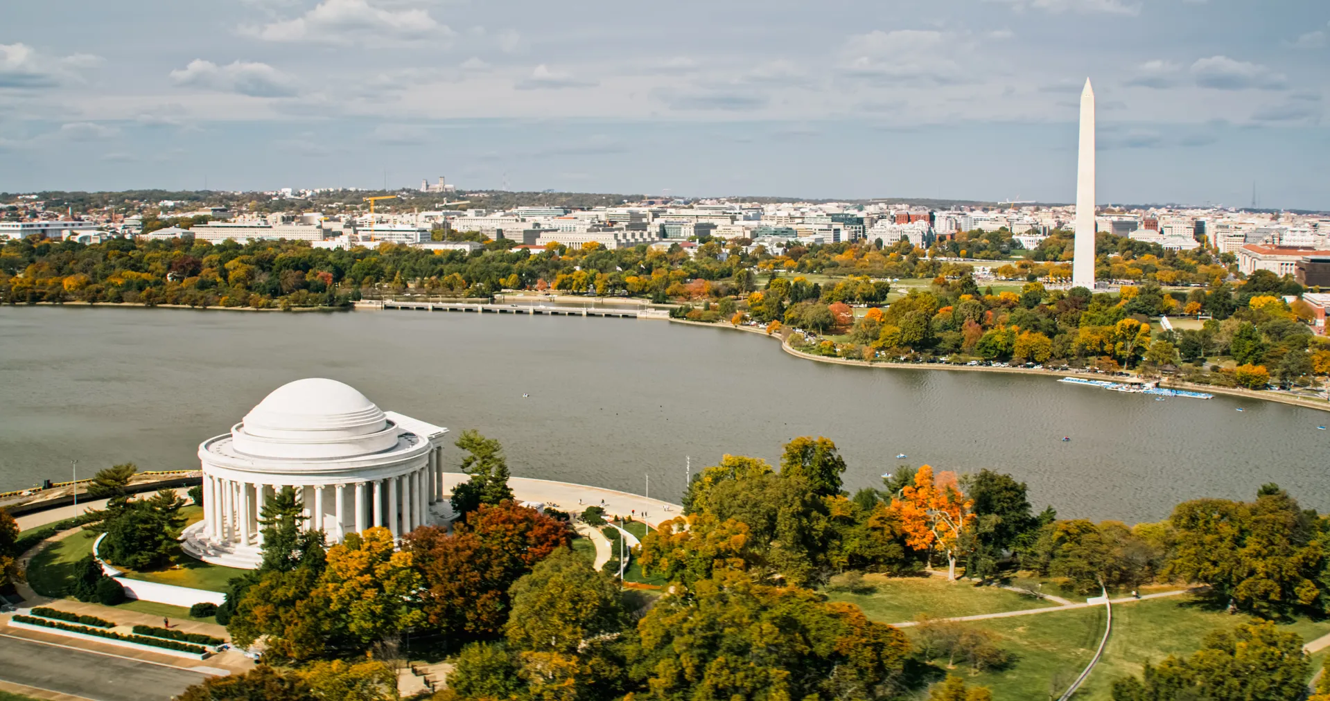
Potomac River
- Length: 405 miles
- Course: Flows from Fairfax Stone in the Potomac Highlands of West Virginia to Chesapeake Bay at Point Lookout, Maryland
- Size of watershed: 14,670 mi²
- States it touches: West Virginia, Virginia and Maryland
- Nearby cities: Harpers Ferry, West Virginia; Bethesda, Maryland; Alexandria, Virginia; Washington D.C.
- Imperiled species: Indiana Bat (endangered), Shortnose Sturgeon (endangered), Wood Turtle (threatened in Virginia, endangered in Maryland), American Eels (endangered), Dwarf Wedgemussel (endangered), Hay’s Spring Amphipod (endangered)
- Why it’s important: Also called “The Nation’s River,” the Potomac is a fixture of daily life in the capital. Descending from its source in the Appalachian Mountains, it flows through a region supporting 118 species of fish, 120 species of birds and 15 species of mussels. Bottlenose Dolphins even raise their young in the river’s tidal waters. However, the Potomac faces many challenges. In 2026, nonprofit American Rivers ranked it as the nation’s most-endangered waterway due to sewage discharge and the water demands of nearby data centers.
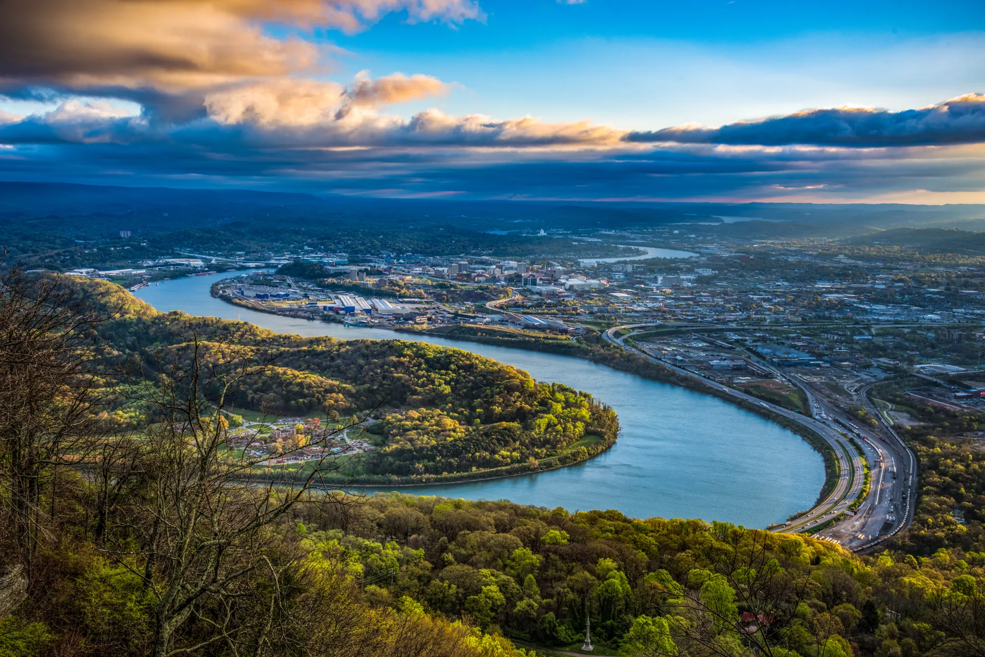
Tennessee River
- Length: 652 miles
- Course: Flows from the confluence of the Holston and French Broad rivers near Knoxville, Tennessee, to the Ohio River near Paducah, Kentucky
- Size of watershed: About 40,000 mi²
- States it touches: Tennessee, Alabama, Mississippi and Kentucky
- Nearby cities: Knoxville, Tennessee; Chattanooga, Tennessee; Huntsville, Alabama
- Imperiled species: Laurel Dace (endangered), Slabside Pearlymussel (threatened), Spotfin Chub (threatened), Pygmy Madtom (endangered), Gray Bat (endangered)
- Why it’s important: The Tennessee River watershed is the nation’s fifth largest and home to “an underwater rainforest” that is one of the most biodiverse freshwater ecosystems on the planet. Its watershed harbors more than 260 kinds of fish — half of all species found in the U.S. and Canada — as well as more than 100 mussels and more than 75 species of crayfish. One of the Tennessee’s largest tributaries, the Duck River, is North America’s most biodiverse river and among the most species-rich waterways on Earth.